Research Area
- OKADA Masaaki
Professor, Landscape Engineering and History of Civil Engineering - OKINAKA Tomoo
Professor, Mechanics of Materials - KAWAI Katsuyuki
Professor, Geotechnical Engineering - SHIMAZU Haruki
Professor, Environmental Engineering - TAKEHARA Kohsei
Professor, Hydraulics - TOMITA Yasuo
Professor, Urban Planning/Transport Planning - HIGASHIYAMA Hiroshi
Professor, Composite Structural Engineering - FUMOTO Takayuki
Professor, Construction Materials, Concrete Engineering - MATSUI Kazuaki
Professor, Urban Microbial Ecology - TAKANO Yasuhide
Associate Professor, Hydrology - TAKABATAKE Tomoyuki
Associate Professor, Coastal Engineering - YANAGIHARA Takao
Associate Professor, Transportation Planning - NAKASHIMA Koji
Assistant Professor, Geotechnical Engineering
OKADA Masaaki
Professor, Landscape Engineering and History of Civil Engineering
Research on Civil Engineering and Industrial Heritage
Research on the Industrial Landscape (Technoscape)
Civil engineering and industrial heritage represent the idea of identifying new cultural values in industrial facilities, such as historic factories and mines, and in civil engineering structures, such as bridges, dams, railroads, fortress and water supply utilities, that have become local treasures over time. My laboratory studies the process of developing civic pride in the history of cultural properties, like those mentioned above, in specific cities (areas). We also investigate the characteristics of distinctive technoscapes formed by these artifacts.
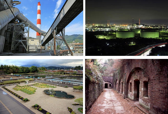
Top: Technoscapes [left: limestone industrial city, Tsukumi ; right: night view of factories (Kurashiki)]
Bottom: Civil engineering heritage [left: water supply utilities (Kanazawa); right: former military facilities (national defence heritage, Wakayama)]
OKINAKA Tomoo
Professor, Mechanics of Materials
Elucidation of Ultrafast Propagation of Crack Growth Phenomena
In the event of the fault failure causing earthquakes and earthquake-caused structure collapse, cracks propagate rapidly leading to overall destruction. Crack growth speed reaches between hundreds to thousands of meters per second. Shedding light on the mechanisms acting in these failures can, for example, be used to predict seismic waves produced at the time of an earthquake and to build safe and secure cities and towns. For experiments handling the phenomena of high-speed propagation, like with cracks, the technique of image analysis is effective, which uses a video camera to take consecutive images of crack propagation for subsequent analysis. In this application, common video cameras are useless for experimental measurements because they can only take about 30 frames per second, while cracks propagate from one to the other end of a test specimen within the duration of one frame. Consequently, it is necessary to use an ultrafast video camera capable of filming one to ten million frames per second and record the progress of cracks with a time scale of one-millionth second (1 µs) or 0.1 millionth second (0.1 µs).
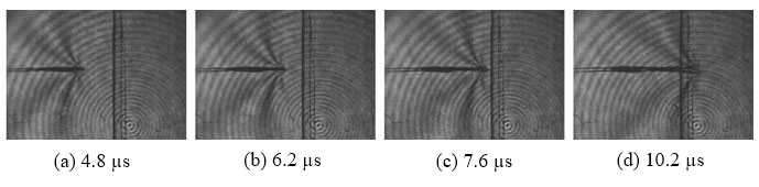
Branching cracks captured with an ultrafast video camera
KAWAI Katsuyuki
Professor, Geotechnical Engineering
Predicting the behavior of earth structures by modeling soil particle-water-air interactions
Structures, such as building foundations and road embankments are constructed of geo-materials. A geo-material is a three-phase mixture comprising soil particles, water, and air. Its deformation and strength characteristics change with its composition ratio. To make a sand castle and dig a tunnel in a sandbox, it is necessary to use suitably moistened and sufficiently compacted sand. The behavior of the sand castle in this instance is also affected by the interaction between soil particles, water, and air. We developed a model of this three-phase interaction to explore the optimal construction and maintenance methods to allow earth structures to resist torrential rains and earthquakes. Numerical simulations enable us to predict the effects of construction and the potential structural behavior during a natural disaster. To pursue greater accuracy in simulation predictions, we also conduct physical prospecting and determine internal state changes in actual structures. Electrical prospecting enables us to know phreatic levels and the extent of rainfall seepage based on measurements of electrical resistance distributions within an earth structure, which are taken by installing electrodes in the surface of the earth structure and passing an electric current between the electrodes.
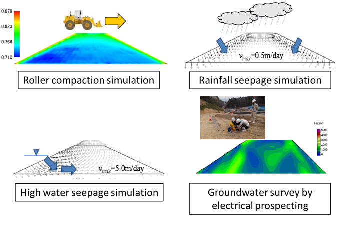
Numerical simulation based on soil/water/air-coupled analysis and physical prospecting
SHIMAZU Haruki
Professor, Environmental Engineering
Study of the impact of low-level environmental contaminants on humans and the ecosystem
While more than 30 million types of chemical substances are known to exist, including unintentional chemical by-products, some exhibit toxicity, such as acute toxicity, cancer-causing properties, reproductive toxicity, mutagenicity, allergenic potency, and aquatic life toxicity. Given that large amounts of chemical substances are released to the environment from their manufacture, usage, and disposal, control is critical and requires tracking what substances exist in the water and atmospheric environment, their extent, and how they influence human health and the ecosystem. My laboratory conducts research focusing on tracking the environmental concentrations of particularly harmful chemical substances. Our activities include acquisition of measurement data for low-level organic contaminants, such as agricultural chemicals and polycyclic aromatic hydrocarbons; identification of contamination sources; and model development for the accurate prediction of environmental concentrations using past measurement data. Our laboratory aims to help build a suitable chemical substances management system by ascertaining the environmental concentrations of harmful chemical substances.
![]()
Conceptual diagram of a chemical substances control system
TAKEHARA Kohsei
Professor, Hydraulics
Development and application of image-based high-accuracy measurement methodology for flow fields
You cannot directly see water or air flow fields with your naked eyes. However, understanding them is very important for human lives. For example, if you understand how water flows in a river during a flood, you will be able to predict, for example, where the bank stress concentrates, and you can take measures to prevent failure.
My laboratory works on the development of technologies to measure various flow fields by combining a technique of making flows visible (flow visualization) and computer-aided image processing. We have developed an ultrafast video camera, an automatic high-resolution particle image tracking algorithm, and a refraction index matching method for transparent solids and liquids. Using these tools, we measure various types of flows.
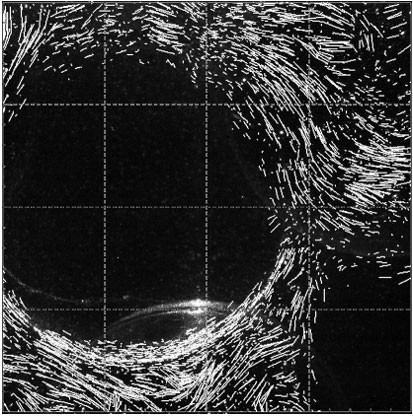
Measurement of water flow in a porous body
TOMITA Yasuo
Professor, Urban Planning/Transport Planning
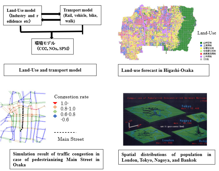
Development and Application of Land Use and Transport Models
In urban areas, the development of transport infrastructure, such as railroads and roads, transforms land use and alters traffic flows and the local environment. These changes are predicted by the technique known as the “land use/transport model.” This model is an effective method for formulating policies to build compact cities in Japan in the era of shrinking cities. I have used the land use/transport model to propose a policy to ensure the city of Higashiosaka is vibrant.
Meanwhile, to mitigate global environmental issues, a shift away from the automobile-centered transport system to a transport system with emphasis on public transport, bicycles, and walking is needed. Ailing transport businesses have discontinued their provincial railway and bus routes one after another, signifying the need for sustainable transport business management. The land use/transport model is also used to develop relevant policies for addressing these challenges. In addition, I am working on factual analyses of cities to augment computer-aided simulations and have participated in an international comparative research project looking into land use and transport in London, Tokyo, Nagoya, and Bangkok.
HIGASHIYAMA Hiroshi
Professor, Composite Structural Engineering
Structural engineering, bridge engineering, and maintenance engineering
Safe and secure infrastructures including bridges, roads, and relating structures are experimentally and analytically investigated through innovative materials, development of new structures, design methodology, and maintenance technology.
I have worked on the development of a new steel-concrete composite slab with the aim of improving the durability and reducing the weight. I have also explored a fatigue design method for headed studs used in steel-concrete composite slabs.
Moreover, I conduct the research for repair and soundness evaluation of bridge slabs using an innovative materials and a falling weight deflectometer (FWD), which measures the deflection of bridge slabs induced by a dropping weight.
Recently, more durable concrete pavement with the application of fiber reinforced concrete has been investigated through static and fatigue bending tests.
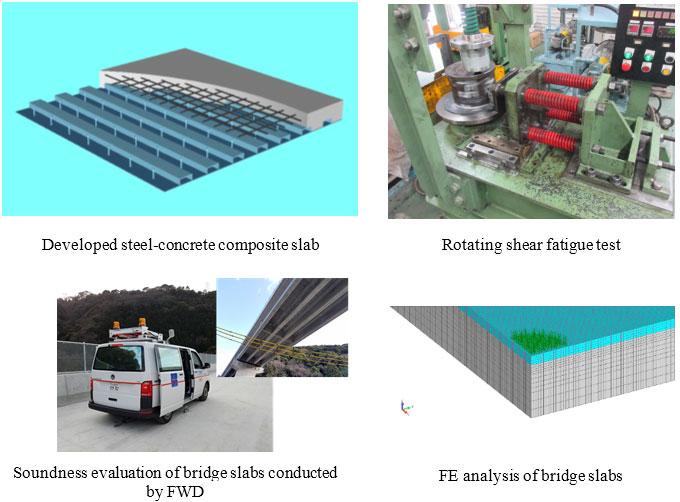
Development of a new steel-concrete composite slab / Soundness evaluation of bridge slabs
FUMOTO Takayuki
Professor, Construction Materials, Concrete Engineering
Use of X-ray CT and image measurement to visualize and elucidate mechanisms involved in the strength and durability of concrete
My research aims to consider construction material design methods that is suitable for the purpose, location, and environment of use though clearing diverse and complex property change laws taking place in construction material under any environment. For the aim, I developed an X-ray CT system to be able to scanning an inside of materials under loads of up to 300kN in 2010. Three-dimensional images in diverse situations and conduct image measurements using the captured images are used in my recent works.
My previous projects focused on internal deformation of material under loads, internal quality changes caused by heating at a high temperature of around 900℃, internal volumetric changes due to drying, internal expansion processes resulting from freezing or ASR, evaluation of internal compaction density after compaction, and pore distributions in porous materials.
In recent years, an increasing number of researchers in Japan and abroad have been investigating the inside of concrete visualized using X-ray CT. Beyond this, I have high expectations for the use of rapidly evolving image-related technologies, such as image processing and 3D printing. This line of research also offers promising avenues for future discoveries applicable to periodic health diagnosis and close inspection of structures.
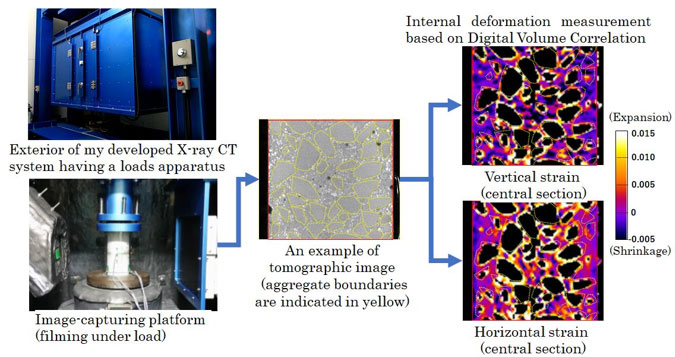
Example of image measurement results of the inside of concrete under compressive stress
MATSUI Kazuaki
Professor, Urban Microbial Ecology
Shedding light on the formation and functions of sewage microbiome
Population growth in urban areas occurs on < 3% of the terrestrial surface, but 60% of global residential water use is attributed to cities. Artificial aquatic environments are rapidly expanding such as sewers and urban rivers. For example, Japan already has more than 440,000 km of sewers, which is longer than the distance between the Earth and the Moon (384,400 km). The current worldwide urbanization signifies the expansion of a new aquatic ecosystem across the globe. However, little effort has been made to date to clarify what microorganisms exist in and in what composition they make up the rapidly expanding aquatic ecosystem.
My laboratory conducts joint research with researchers in Japan and abroad with the aim of elucidating the actual state of microbial ecosystems formed in urban bodies of water, as well as understand antibiotic resistance and other genetic dynamics in the new ecosystem.

My research goal is to clarify microbial ecosystems in artificial bodies of water spreading in urban areas.
TAKANO Yasuhide
Associate Professor, Hydrology
Investigating heat and moisture transfer in frozen soil and the frost heaving process
The heat and moisture transfer in frozen soils are the dominant factors to estimate the runoff volume from the soil. However, the characteristics of heat and moisture properties of frozen soils, such as the soil freezing curve, are still unknown, and it is necessary to identify them in order to construct an effective analytical model for heat and moisture transfer in frozen soil. In addition, the process of soil deformation, such as frost heaving, is also unknown. We are attempting to identify these physical properties and elucidate the process of soil deformation by using various sensors and X-ray CT in soil freezing experiments.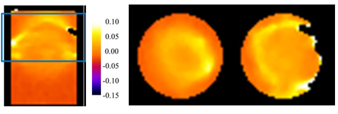
Volumetric strain distribution observed in a frozen sand bed (vertical and horizontal sections)
TAKABATAKE Tomoyuki
Associate Professor, Coastal Engineering
Towards a sustainable coastal area.
Once a significant coastal disaster occurs, coastal areas would suffer from devastating damage, as evidenced by major historical coastal disasters such as the 2004 Indian Ocean Tsunami, 2011 Tohoku Earthquake and Tsunami and 2018 Typhoon Jebi. This coastal engineering laboratory aims to protect human lives and properties from such devastating coastal disasters and contribute to developing a sustainable coastal area. To achieve this goal, we have conducted a variety of research relevant to coastal engineering, including field surveys, hydraulic experiments, and numerical simulations. For instance, generation and propagation mechanism of landslide-generated tsunamis has been investigated through our laboratory experiments. We also have developed an agent-based tsunami evacuation simulation model, which is able to reproduce a variety of evacuation behavior during a significant tsunami event, and applied it to identify tsunami risks in various coastal areas around the world. Recently, the application of state-of-the-art research tools, such as artificial intelligent and virtual reality, to coastal engineering problems has actively been studied in the laboratory. For instance, we have been developing wave prediction models, based on a deep-learning technique, and evacuation assistance tools, based on VR technique, hoping that such innovative techniques would lead to improve the sustainability of coastal communities in the world.
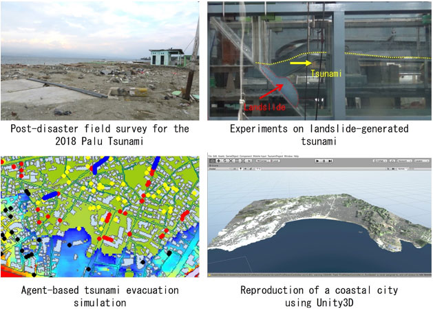
Examples of most recent research accomplishments
YANAGIHARA Takao
Associate Professor, Transportation Planning
Barrier-free and universal design of public spaces and social welfare-oriented urban development
Given the highest population aging rate in the world, it is urgent for Japan to promote relevant urban development in terms of hardware and software. In today’s advanced stage of globalization, many countries are striving to incorporate barrier-free designs. The barrier-free perspective is given an important position in the United Nations’ sustainable development goals (SDGs). At the same time, many provincial cities in Japan are predicated on the use of automobiles. Accordingly, elderly people unable to drive a car or without a driver’s license lack means of transportation and face difficulties going out for shopping or medical care.
Against this backdrop, my laboratory conducts research on the barrier-free and universal design of public spaces and public transport services.
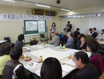
Photo: Barrier-free workshop attended by, among others, students taking part in my seminar
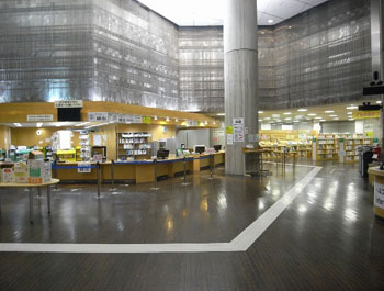
Photo: UD floor system, a product of joint development
NAKASHIMA Koji
Assistant Professor, Geotechnical Engineering
Evaluating the safety of earth structures from both microscopic and macroscopic points of view
We have seen frequent failures of earth structures, such as mountainsides, river levees and other natural terrain, due to heavy rainfall occurring because of climate change. Soil is composed of gravel, sand, clay, and other particles, which differ in size, shape, and properties. As such, it is a material known to be difficult for systematic theorization of its mechanical phenomena. Moreover, water, including precipitation, river water, and seawater, flows through soil. This action, termed “seepage”, can cause structural changes in soil. Structural changes in soil substantially affect the stability of slopes and other earth structures. Consequently, it is necessary to look closely into the mutual relationship between seepage and changes in soil structure. However, it is not a simple task to study how water flows through soil and what changes occur in the soil structure. In recent years, developments have advanced in highly accurate numerical simulation and image analysis technologies, which are vigorously applied in geotechnical engineering. By making full use of these technologies, my research evaluates the safety of earth structures.
![]()
Model experiment of a river levee assuming flood events (left), and evaluation of deformation by photographic analysis (right)